United Kingdom. Geographic Location, Climate, Population
United Kingdom
The United Kingdom.
Geographic Location
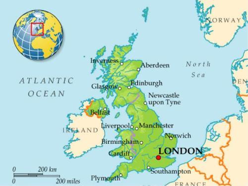
The official name of the country we usually call «England» and occasionally «Great Britain» is the United Kingdom of Great Britain and Northern Ireland. The United Kingdom is situated on the group of islands lying just off the mainland of north-western Europe. The British Isles include Great Britain, Ireland and a number of smaller islands. The total area of the British Isles is 325000 square km.
Many ages ago the British Isles formed a part of the continent. The rocky highlands of Scotland, for example, resemble the Norwegian coast. Another evidence that the islands were the part of the continent is the shallow ness of the water between them and the mainland.
Now Great Britain is separated from the continent by the English Channel, the narrowest part of which is called the Strait of Dover. The British Isles are surrounded by the shallow waters of the Irish Sea and the North Sea, the Norwegian Sea, the North Channel and the Atlantic Ocean.
There are wild desolate mountains in the northern Highlands of Scotland. The Pennine Range in northern England and the Cambrian Mountains in Wales are much lower.
The rivers of the region are short and of no great importance as waterways. The longest of them is «the Father of London», the Thames, which is a little over 200 miles. Britain’s princi pal ports are London, Liverpool, Manchester and Glasgow. They have splendid harbours, for the coast line is very indented. Owing to the shape of the country, any point in Great Britain is no more than 70 miles from the sea.
Questions:
1. What is the official name of the country we call Great Britain?
2. Is United Kingdom situated on the mainland?
3. What are the evidences that the Islands were part of the continent?
4. What is the Strait of Dover?
5. What are the British Isles surrounded by?
6. Are there any rivers in that region?
7. What are main ports of Britain?
Соединенное королевство.
Географическое положение
Официальное имя страны, которую мы обычно называем «Англия» и иногда — «Великобритания», — Соединенное Королевство Великобритании и Северной Ирландии. Соединенное Королевство расположено на группе островов, лежащих неподалеку от материка на северо-западе Европы. Британские острова включают Великобританию, Ирландию и множество более мелких островов. Общая площадь островов составляет 325 тысяч кв. км.
Много веков назад Британские острова были частью континента. Скалистые горы Шотландии похожи на побережье Норвегии. Другое доказательство того, что острова были частью континента, — это небольшая глубина вод между ними и материком.
Сейчас Великобритания отделена от континента проливом Ла-Манш, самая узкая часть которого называется Дуврский пролив. Британские острова омываются мелководными Ирландским, Северным и Норвежским морями, Северным проливом и Атлантическим океаном.
В северных районах Шотландии расположены дикие без-людные гористые места. Цепь Пеннинских гор на севере Англии и Кембрийские горы в Уэльсе гораздо ниже. Реки в этом регионе короткие и не могут быть использованы для судоходства. Самая длинная из них — «отец Лондона», Темза, длина которой немногим больше 200 миль. Главные порты Британии — Лондон, Ливерпуль, Манчестер и Глазго. У них прекрасные гавани из-за изрезанности береговой линии. Благодаря форме острова, любая точка страны находится на расстоянии, не превышающем 70 миль от моря.
Climate of Great Britain
Due to the geographic location of Great Britain the type of the climate is oceanic. There are no extreme contrasts in temperature in Britain because of the current of warm water flowing from the gulf of Mexico called the Gulf Stream.
Average British temperatures do not rise above 32”C in summer and do not fall below — 10°C in winter.
The prevailing winds from the ocean to the south-west bring rainfall throughout the year. The total national rainfall average is over 1100 mm annually. March to June tend to be a driest months, September to January the wettest.
The fogs of London, often made severe by mixture with city smoke, have worldwide reputation.
The rivers of the Great Britain are abundant, and they never freeze. The main rivers are the Thames, the Tyne, the
Severn, ihe Mersey; the biggest lakes are the Loch Lomond, the Lough Neagh. A considerable area of land is covered by meadows and heaths. The grass remains green all the year round. Thanks to climate conditions, Britain in truth looks like one great well-ordered park with its old trees, green meadows and hedges.
Questions:
1. What kind of climate does Great Britain have?
2. Are there extreme contrasts in temperature? Why?
3. What are the average temperatures?
4. What are the driest (the wettest) months?
5. What are the main rivers and lakes?
Климат Великобритании
Благодаря географическому положению Великобритании климат ее океанический. В Британии не существует больших перепадов температур из-за теплого течения, идущего из Мексиканского залива и называемого Гольфстрим. Средняя температура в Британии не превышает +32°С летом и не опускается ниже -10 С зимой.
Преобладающие ветры, дующие с океана на юго-запад, приносят осадки круглый год. Среднегодовое количество осадков превышает 1100 мм. Месяцы с марта по июнь —• самые сухие, а с сентября по январь — самые влажные.
Лондонский туман, часто смешивающийся с дымом, имеет мировую репутацию.
Реки Великобритании бурные, поэтому никогда не замерзают. Главными реками являются Темза, Теин, Северн, Мерси; самыми большими озерами — Лох-Ломонд, Лох-Ней.
Значительная часть земли покрыта лугами и вересковыми пустошами. Трава остается зеленой круглый год. Благодаря климатическим условиям Британия выглядит как один огромный, хорошо ухоженный парк с ее старыми деревьями, зелеными лугами и живыми изгородями.
Population
The British Isles are the home of four nations — English, Scottish, Welsh and Irish. Even though foreigners often call all British people «English», and sometimes have difficulty in appreciating the distinctions, the component nations of the United Kingdom are well aware of their own individual characteristics. The Scots, Welsh and Irish regard themselves as largely Celtic peoples, while the English are mainly Anglo- Saxon in origin.
British society as a whole does not have a uniform cultural identity. In 1988 the population of the United Kingdom was about 57 million inhabitants. This figure gives a population density of 600 persons per square mile (284 per square km). England has an average density of 980 persons per square mile (364 per square km). This average does not reveal the even higher densities in some areas of the country, such as south-east parts. Within Europe only the Netherlands has a higher population that England.
Questions:
1. How many nations live in the Great Britain? What are they?
2. What nations regard themselves as Celtic people?
3. What nation is Anglo-Saxon?
4. What was the population in 1988?
5. What Europe country has a higher population than England?
Британские острова — дом четырех народов: английского, шотландского, уэльского и ирландского.
Хотя иностранцы часто называют всех британцев англичанами и им иногда трудно найти отличия между ними, но нации, составляющие Соединенное Королевство, хорошо знают свои индивидуальные характеристики. Шотландцы, уэльсцы и ирландцы, в основном, считают себя кельтами, тогда как англичане — англосаксонского происхождения. Британское общество в целом не имеет общей культурной характеристики.
В 1988 году население Соединенного Королевства составляло около 57 миллионов жителей. Эта цифра показывает плотность населения — 600 человек на кв. милю (234 — на кв. км). В Англии средняя плотность населения составляет 930 человек на кв. милю (364 на кв. км). На юго-востоке эта цифра даже выше. В Европе только в Нидерландах плотность населения выше, чем в Англии.
Источник: 100 тем английского языка. Авторы Каверина В. Бойко В. Жидких Н.